Caddie Professional comes complete with a number of Specialised Applications which are designed for specific fields of practice such as:
- AEC & 3D
These two applications run parallel as they are used in conjunction to one another. The AEC application can be used for both 2D and 3D drawings and modelling. This varies from drawing walls, windows, doors, stairs, slabs, roofs etc. to the creation of sections and elevations from the model.
The 3D application is used to set up working planes and your default views as well as 3D orbiting options.
- Architectural
This is a 2D application used to generate 2D Architectural drawings. This includes the creation of walls, windows, doors, stairs, sections, symbols, scheduling, areas, SANS calculations and Artistic tools.
The AEC application is a more intelligent way of creating Architectural models and drawings.
- Mechanical
This application is a 2D application and helps you to draw machine symbols, pipes, PC diameters, threads, nuts, bolts, diagrams, links, basic developments, advanced developments and welding symbols.- Survey & DTM
With the survey application you can set your surveyor mode, place coordinates, draw by polar or survey coordinates, add join text, insert survey points, draw transition curves, coordinate import and export, import gps coordinates, load satellite images and use survey & gps measure tools.
The survey applications works together with the DTM (Digital Terrain Modelling) to create 3D terrain models of a site, create 3D contours, draw long sections, create platforms and calculate site volume differences.
- Civil
This application is used to add finishes to civil and survey drawings. They add information like powerlines, fences, embankments, vehicle turning circles, sewer, stormwater and beam details.
- Steel
Standard steel profile and sizes can be found in this application. It helps you to draw steel profiles in section and elevation and helps you in the drawing of bracing details. You can also draw industrial handrails, stairs and cat ladders.
- Vio Photorealistic Rendering
Vio is an add-on application used to turn your 3D model into a high quality photorealistic image or render. In this application you assign materials and textures to objects, ad natural and artificial lights and create an image that can be used for marketing purposes.
- Caddie GIS & Asset Management Application
Seamlessly integrated into Caddie Professional, Caddie GIS provides an uniquely tailored solution for design professionals that will dovetail effortlessly into your workflow. Whether you need just a simple 2D location plan incorporating local services and infrastructure, or a full 3D CAD building set into an aerial imagery-draped digital terrain site model, Caddie Pro+ GIS deliver the tools you need.
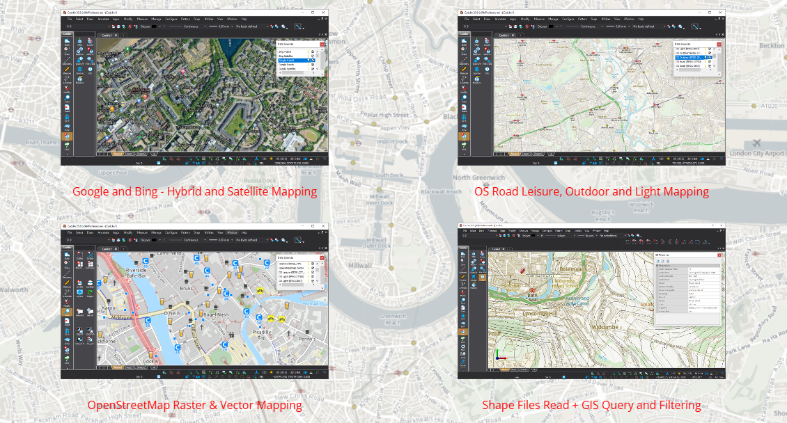
Stream Google, Bing, OpenStreetMap and Ordnance Survey raster tiles directly into your CAD drawings.
Caddie Pro + GIS is your perfect solution for information procurement, production, assimilation, and presentation.
Read vector SHP files direct, or add data sources to your own local, or Cloud Databases to minimise online storage costs.
Combine data sources to construct that comprehensive appraisal of a location or area based on the latest information available.
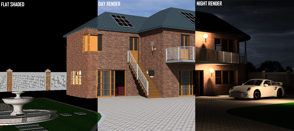
Visual Image Output (Vio) photorealistic rendering is the third course within the Caddie 'Specialist Application' category of online courses.
It is aimed at users who are competent with drawing using Caddie software and are wanting to quickly and easily create high quality 3D renderings from existing Caddie 3D models or any other DWG or DXF files.
During the course you will learn to attach materials to objects, manipulate and store views, define natural and artificial lighting and create photorealistic images from 3D models. You will also learn how to use Caddie Vio to perform quick and easy sun studies complete with accurate shadows from your 3D models
Once you have enrolled you will have 12 weeks to complete the course. You will be able to study anytime and anyplace that you have an internet connection and Caddie running. Once you have successfully completed and received a certificate for the course you will have unlimited access to revisit the course.
Click on each module title, watch the video and then answer the questions to complete each lesson. Some of the modules have more than one lesson and practical exercises to complete using Caddie. You must work through each of the modules and lessons sequentially, to complete the course.
To gain a Certificate of Achievement, each module and the accompanying exercises and questions must be completed. There is a pass mark of 75% and a minimum length of time to spend in each lesson.

Caddie Survey Application is the first course within the Caddie 'Specialist Application' category of online courses. It is aimed at users who are competent with drawing using Caddie software and have a reasonable understanding of the principles and terminology of surveying.
You can set your surveyor mode, place coordinates, draw by polar or survey coordinates, add join text, insert survey points, coordinate import and export, import GPS coordinates, load satellite images and use survey and GPS measure tools.
The Caddie Survey online training will support you to get the best out of the features, without having to wait to attend a face to face course.
Successful completion of the Caddie Basic Online training course, Caddie Basic classroom course or the equivalent self-taught experience should be viewed as a minimum requirement.
Once you have enrolled you will have 4 weeks to complete the course. You will be able to study anytime and anyplace that you have an internet connection and Caddie running. Once you have successfully completed and received a certificate for the course you will have unlimited access to revisit the course.
Click on each module title, watch the video and then answer the questions to complete each lesson. Some of the modules have more than one lesson and practical exercises to complete using Caddie. You must work through each of the modules and lessons sequentially, to complete the course.
To gain a Certificate of Achievement, each module and the accompanying exercises and questions must be completed. There is a pass mark of 75% and a minimum length of time to spend in each lesson.
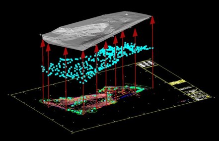
The Caddie Digital Terrain Modelling Application is the second course within the Caddie 'Specialist Application' category of online courses. It is aimed at users who are competent with drawing using Caddie software and have a reasonable understanding of the principles behind terrain modelling.
For anyone involved in Civil Engineering, Surveying or the Construction Industry dealing with real world sites where levels can be anything but flat, Caddie's Digital Terrain Modelling Application (DTM) provides the perfect tool for preparing the site models, sections and contours needed to fully develop a scheme.
With Caddie DTM you can create 3D site models and multiple sections quickly, viewing your sites from any angle to get a better appreciation of the opportunities and challenges they offer. Even draping images such as aerial photographs to view site features.
The Caddie DTM online training will support you to get the best out of the features, so you can be modelling and sectioning your sites in minutes without having to wait to attend a face to face course.
Successful completion of the Caddie Basic Online training course, Caddie Basic classroom course or the equivalent self-taught experience should be viewed as a minimum requirement.
Once you have enrolled you will have 4 weeks to complete the course. You will be able to study anytime and anyplace that you have an internet connection and Caddie running. Once you have successfully completed and received a certificate for the course you will have unlimited access to revisit the course.
Click on each module title, watch the video and then answer the questions to complete each lesson. Some of the modules have more than one lesson and practical exercises to complete using Caddie. You must work through each of the modules and lessons sequentially, to complete the course.
To gain a Certificate of Achievement, each module and the accompanying exercises and questions must be completed. There is a pass mark of 75% and a minimum length of time to spend in each lesson.
Caddie Geographic Information System is the fourth course within the Caddie 'Specialist Application' category of online courses.
It is aimed at users who are competent with drawing using Caddie software and want to incorporate spatial data such as mapping, local services and infrastructure into their drawings, as well as using Caddie to manage and populate GIS data sources.
During the course you will learn to:
- Understand Caddie's use of coordinate reference systems.
- Combine available vector and raster GIS information with your own drawings and models.
- Convert between coordinate systems.
- Measure and interrogate locations using different Coordinate Reference Systems.
- Query, update, edit and manage properties and attributes of data sources.
- Create GIS databases.
- Stream Google, Bing, OpenStreetMap and Ordnance Survey raster tiles directly into your CAD drawings.
- Read vector SHP files direct, or add data sources to your own local, or Cloud Databases to minimise online storage costs.
- Combine data sources to construct that comprehensive appraisal of a location or area based on the latest information available.
Once you have enrolled you will have 12 weeks to complete the course. You will be able to study anytime and anyplace that you have an internet connection and Caddie running. Once you have successfully completed and received a certificate for the course you will have unlimited access to revisit the course.
Click on each module title, watch the video and then answer the questions to complete each lesson. Some of the modules have more than one lesson and practical exercises to complete using Caddie. You must work through each of the modules and lessons sequentially, to complete the course.
To gain a Certificate of Achievement, each module and the accompanying exercises and questions must be completed. There is a pass mark of 75% and a minimum length of time to spend in each lesson.